
GIS Software for Commercial Real Estate Developers
Turn location data into commercial development wins. Latapult’s dynamic GIS mapping software and CRE development tools give you the insight to choose sites, reduce risk, and power confident investments across infill, redevelopment, and new growth opportunities.


Make Faster, Smarter Decisions
Why Commercial Real Estate Development Teams Rely on Latapult

Deliver deeper insights to informed clients
Gain a competitive edge with commercial real estate mapping software that overdelivers on rising expectations.

Outpace online competition
Provide intelligence and context that goes beyond public commercial property maps and free online tools with some of the best mapping software available.

Pinpoint high-potential locations
Use CRE development data to assess market and logistical factors that guide success from the start.

Access current, detailed parcel data
Leverage up-to-date parcel data and property information to validate site decisions with confidence.

Spot overlooked site advantages
Reveal parcel details like lot size, shape, access points, and surrounding features with commercial real estate analytics software that highlights opportunities others miss.

Streamline team collaboration
Share market data and mapping insights in one platform for faster, unified decisions.
Turn Location Decisions into Lasting Wins
As a commercial developer, you know choosing the right site is never just about the location on a map. Parcel shape, access points, surrounding infrastructure, and market trends all have the power to make or break your next project.
Latapult’s commercial real estate mapping software puts the full picture in front of you, combining up-to-date parcel data, market insights, and collaborative tools in one easy-to-use platform.
- Pinpoint locations using market and logistical insights that drive CRE
development success
- Spot parcel details like size, shape, and access that give your project a
competitive edge
- Work with accurate, current parcel information to make low-risk site
selections
- Share maps, data, and insights so your team stays aligned from day one
- Deliver data-backed recommendations powered by commercial real estate
analytics software
We work with commercial developer clients nationwide. Put your trust in our experienced hands.
-
300+
Businesses nationwide
Supported in uncovering insights that transform projects.
-
50x
Faster land research
To justify, approve, and negotiate land deals quickly and strategically.
-
$1K+
In savings a month per user
On resources, labor, and more.
-
$1M+
In GIS data
Powering environmental, demographic, geospatial, and topographic insights.
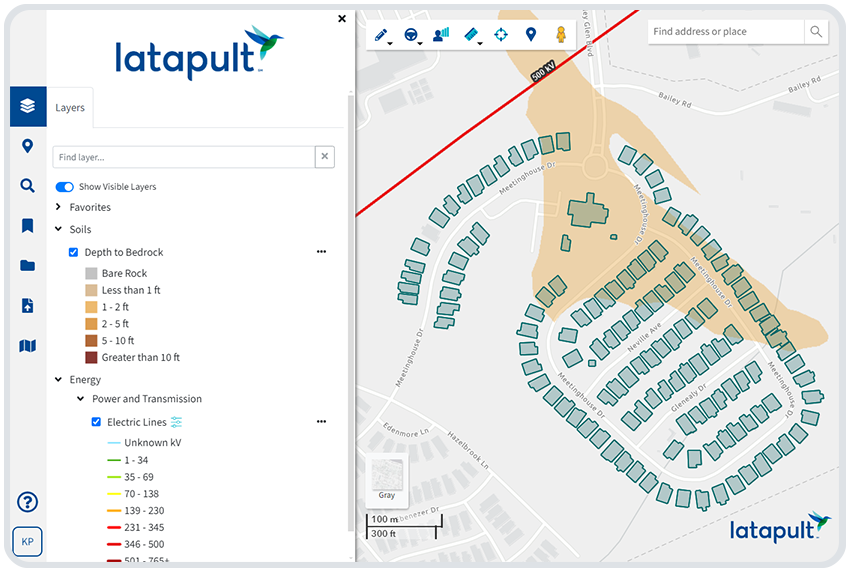
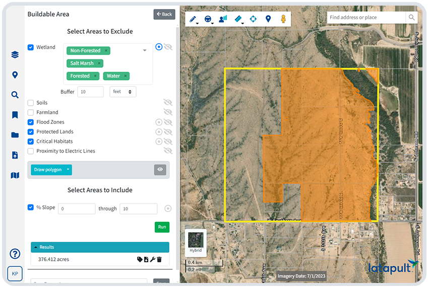
GIS Land Data Layers Built for Civil Engineering & Construction Projects
Determine feasibility before you break ground.
Evaluate commercial real estate development potential with the location intelligence you need to move forward confidently. Latapult’s commercial real estate mapping and analytics software combines market trends, property details, and environmental factors so you can quickly assess whether a site is worth pursuing.
Key datasets include:
- Property Data – Access up-to-date ownership records, property
transactions, acreage, and value per acre
- Environmental Data – Identify flood zones, wetlands, and other factors
that may impact buildability
- Market Data – Analyze existing commercial developments and area trends
to gauge project viability
- Boundary Data – Review municipal boundaries and relevant jurisdictional
overlays
- Census Data – Understand local demographics, income, and population
density
- Points of Interest – See proximity to amenities that add value to your
project
- Traffic Counts – Measure vehicle volume to understand potential
customer flow
- Custom Data – Import your own datasets into the platform for a complete
view of CRE development feasibility
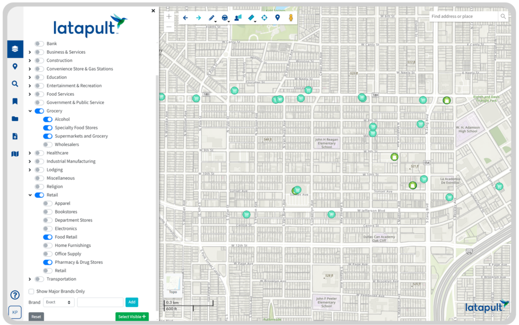
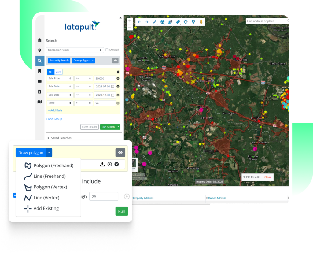
Dynamic GIS Mapping Tools for Smarter Site Evaluation
- Run property queries to find land to test site plans
- Measure travel distance and proximity to key amenities and points of
interest
- Export personalized PDF maps and data tables to present to clients
- Highlight surrounding features that impact commercial real estate
development
- Use visual maps to communicate project potential more clearly than email or calls
Custom GIS Solutions for Commercial Development
Some projects call for more than an out-of-the-box GIS platform. When your development decisions require deeper insight, our experts can customize Latapult to fit your data, workflows, and goals.
- Import and manage property and market data specific to your projects
- Set up workflows to track site evaluation, approvals, and build phases
- Integrate with external systems like CRMs, project management tools, or
databases
- Work directly with a GIS expert to adapt Latapult to your development
process


Frequently Asked Questions
-
How do I evaluate a parcel’s access to amenities and infrastructure?
To understand a property’s value, you need to know more than just its boundaries. You also need insight into what surrounds it. Latapult’s commercial real estate mapping and analytics software lets you measure a parcel’s distance to schools, parks, hospitals, transit, and other essential amenities, along with existing infrastructure that supports development. These layers of data help you assess not just where a property sits but how well it connects to the community around it.
-
What tools help with commercial site planning and feasibility?
Effective site planning and feasibility analysis require having the complete picture before committing to a location. Latapult brings together property ownership, zoning, market trends, demographics, traffic counts, and environmental data in one platform.
You can run property queries to find land for your site plan, measure proximity to amenities, and export professional maps and reports for stakeholders. This streamlines decision-making and reduces guesswork.
-
Why use GIS for commercial real estate development?
GIS technology gives developers the ability to layer and analyze multiple datasets and uncover the true potential of a site. With Latapult, you can see existing infrastructure, environmental risks, surrounding amenities, and demographic patterns all in one map-based view. This speeds up due diligence and improves communication with clients and partners.
-
How accurate is Latapult’s property data?
Latapult sources its parcel, transactions, and market data from verified public and commercial providers, updating it regularly to ensure accuracy. This includes ownership records, zoning codes, environmental layers, and market indicators. Accurate data is essential for developers to make informed site selection and planning decisions.
-
Does Latapult work for multi-site or regional development projects?
Yes. Whether you are evaluating one parcel or hundreds, Latapult’s commercial real estate mapping software helps organize, compare, and share findings across your teams. Bookmark top sites, group candidates by priority, and run consistent evaluations for projects that span multiple markets.
-
What data should I review before selecting a commercial site?
Before selecting a site, you should review zoning codes, ownership records, environmental risks, market trends, demographic data, traffic counts, and proximity to key amenities. Latapult brings all of this information together in one platform, allowing you to quickly see whether a property meets your development goals and client needs. Having these datasets in a single view reduces research time and improves decision quality.
-
How can I compare multiple sites efficiently?
Comparing sites efficiently means having standardized data and analysis tools for each location. With Latapult, you can bookmark and group sites, apply the same zoning, market, and environmental filters, and run identical feasibility checks on every property. This side-by-side view helps spot the best opportunities faster and justify recommendations with clear, consistent data.