
How We Serve Our Partners
Explore the Capabilities of Latapult's GIS Mapping Software
Bigger Data. Faster Maps. Stronger Decisions.
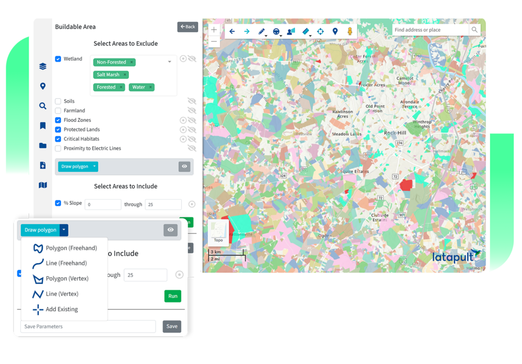
Land Evaluation and Site Assessment
Turn Land Data Into Site Selection Decisions
With comprehensive GIS data and dynamic analysis tools, Latapult helps site selection teams understand opportunity, surface risk, and validate decisions early.


Complete Land Intelligence
All the data you need, already organized. Access comprehensive GIS data across environmental, demographic, geospatial, and topographic layers.

Faster Research, Fewer Roadblocks
Move from questions to answers in minutes. Eliminate manual research and disconnected systems to dramatically reduce the time it takes to evaluate and justify land decisions.

Clear Criteria Validation
Know whether land meets your requirements, fast. Analyze parcels against detailed, project-specific criteria to identify both opportunity and risk before decisions are made.
Land Development Software
Support Development With Reliable Land Data
Development decisions depend on current, accurate information. Latapult keeps critical land data accessible and visible so teams can navigate complexity with confidence.

Scalable Development Oversight
Manage more projects with less guesswork. Track multiple sites and development stages in one platform, making it easier to prioritize effort and manage risk.

Unified Project Visibility
Keep teams and partners on the same page. Create a shared view of development data that supports collaboration across planners, engineers, and project stakeholders.

Fewer Data-Driven Delays
Reduce friction caused by incomplete information. Identify constraints earlier and avoid surprises that slow development decisions and approvals.
Land Acquisition Software
Land acquisition moves fast, but smart decisions take more than speed alone. Latapult helps teams explore, evaluate, and compare sites with clear, reliable land data.


Side-by-Side Comparisons
See how opportunities stack up. Compare multiple sites using consistent criteria to make prioritization easier and decisions more grounded.
Simplified Due Diligence
Spend less time searching for answers. Bring parcel, ownership, and land intelligence together in one place to reduce manual research and unnecessary delays.

Clear, Shareable Insights
Communicate opportunities with ease. Create maps and visuals that help convey site value clearly to investors and internal stakeholders.


