
Land Intelligence for Data Center Construction & Relocation
Find qualified sites lightning fast with comprehensive tools, up-to-date data, and dynamic mapping insights into energy infrastructure, fiber proximity, and community context.
Make Faster, Smarter Decisions
Solving the Toughest Parts of Data Center Site Selection

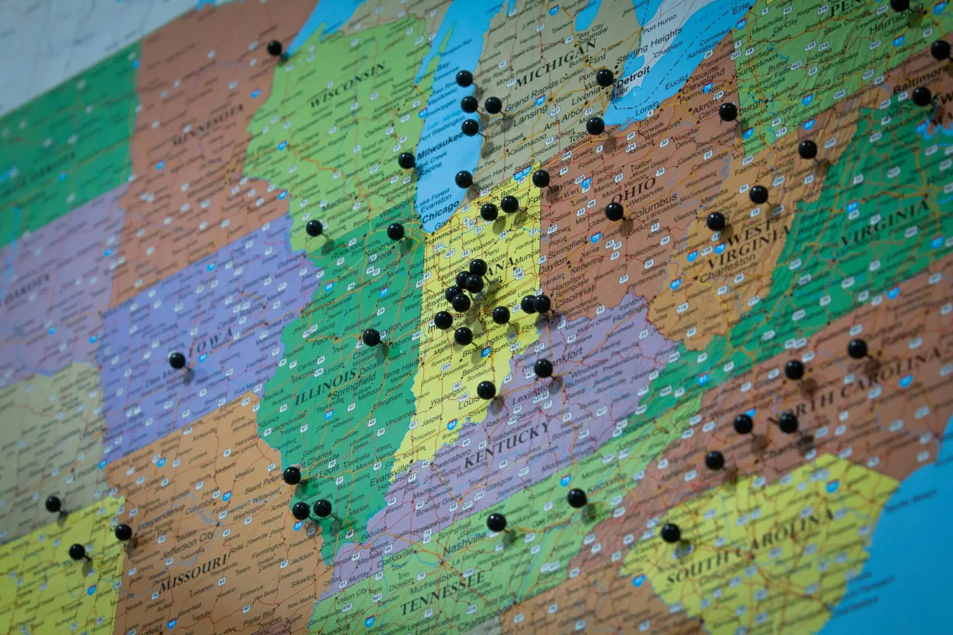
Find the Right Locations, Faster
Identify sites with the necessary infrastructure, acreage, and location without the wait.

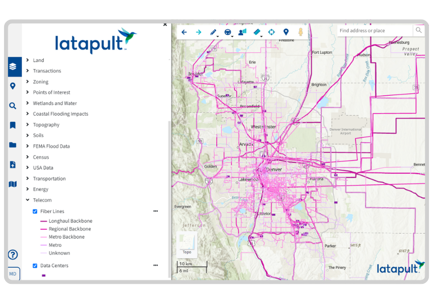
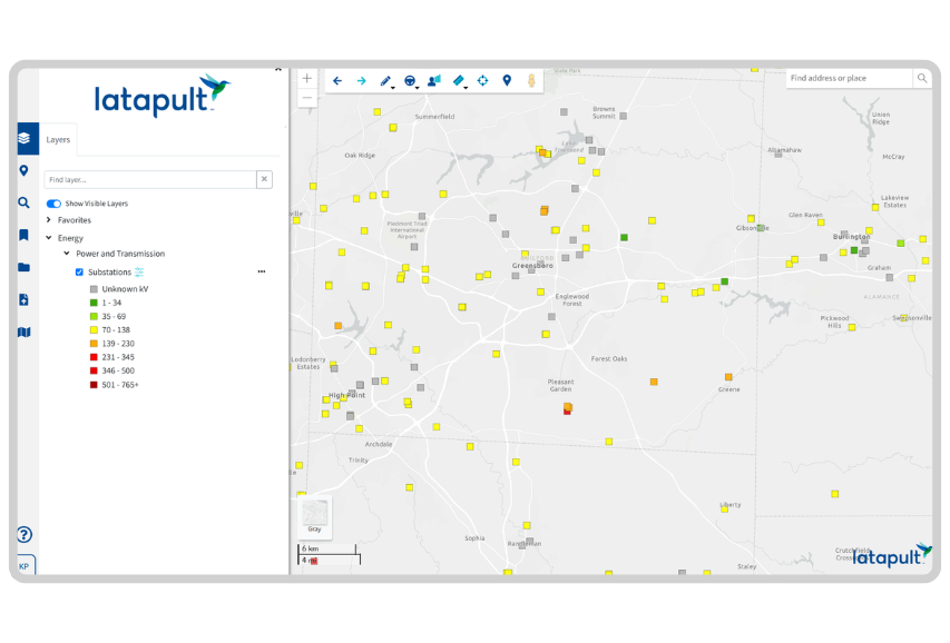
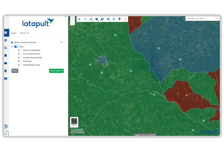
See Infrastructure in Context
Visualize where fiber and transmission lines overlap with parcel and environmental data.

Validate Sites Before You Invest
Get early visibility into flood risk, topography, and development limitations.

Keep Teams Aligned in Real Time
Share pins, bookmarks, and updates across your entire project team.

Understand Full Community Impact
Use census and POI data to assess demographic information, schools, and surrounding infrastructure.

Stay Ready to Scale
Customize data, track projects, and expand workflows as your footprint grows.
The Challenge
Latapult for Data Center Construction Projects
Designed to help find viable sites without slowing you down.
- Run proximity searches based on distance from fiber lines, substations, or
existing utility zones
- Filter sites by acreage, ownership, or value
- See where infrastructure overlaps to prioritize high-potential zones
- Identify existing data centers nearby for context or adjacency planning
- Eliminate delays from toggling between fragmented tools
The Solution
GIS Data That Keeps Every Variable Visible
No more guessing what’s around or under the land. Quickly find the data you need, including:
- Power and transmission line locations
- Fiber networks
- Parcel ownership and transaction history
- FEMA flood zones and topography
- Census and community demographics
- Road, rail, and port access
Built-In Tools That Speed Up Site Discovery
- Drop pins to mark and annotate potential sites
- Use bookmarks to track and group top candidates
- Apply the Buildable Area Tool to calculate usable land instantly
- Export maps to share with executives and partners
- Import external site plans or overlays
- Use filters to spot emerging zones before they’re widely recognized
Tailored for Data Center Siting and Strategy
Unlock deeper insights with our premium add-on for customizable layers.
Designed for teams who need tailored control over infrastructure planning and siting strategy.
- Add internal data like fiber overlays, utility capacity, or easements
- Customize filters for grid capacity, service areas, or proximity thresholds
- Tag sites based on operational fit, like cooling potential or footprint
- Track infrastructure gaps that could increase project cost
- Build long-range siting maps for phased development or future relocation
We work with data center developers and operators nationwide. Put your trust in experienced hands.
-
300+
Businesses nationwide
Supported in uncovering insights that transform projects.
-
50x
Faster search
To quickly and strategically respond to service and work order questions.
-
$1K+
In savings a month per user
On resources, labor, and more.
-
$1M+
In GIS data
Powering environmental, demographic, geospatial, and topographic insights.


Frequently Asked Questions
-
What should I consider when building a data center?
Key considerations when building a data center include:
- Power and Cooling Infrastructure: Ensure access to reliable power sources and efficient cooling systems.
- Connectivity: Proximity to fiber networks for high-speed data transmission.
- Scalability: Availability of space and resources for future expansion.
- Compliance with Standards: Adherence to industry standards that provide energy efficiency requirements tailored for data centers
- Risk Assessment: Evaluation of environmental risks like flooding or seismic activity.
Utilizing Geographic Information System (GIS) tools can aid in assessing these factors comprehensively during the planning phase.
- Power and Cooling Infrastructure: Ensure access to reliable power sources and efficient cooling systems.
-
What is a good location for a data center?
An optimal data center location typically offers:
- Robust Power Supply: Access to high-capacity and redundant power sources.
- Network Connectivity: Close proximity to major fiber optic routes.
- Low Environmental Risk: Areas with minimal exposure to natural disasters.
- Favorable Climate: Cooler climates can reduce cooling costs.
- Regulatory Environment: Regions with supportive policies and incentives for data center operations.
These factors contribute to operational efficiency and reliability, which are critical for data center performance.