4 Questions to Answer Before Investing in your Next Solar Land Development Project
September 10, 2020
We’ve had developers come to us searching for acres of property that are ideal for solar land development, but they didn’t know how to evaluate their options for the best investment. There are several key factors that play into whether a solar farm will be successful.
Considerations for Solar Development
From property location to land fertility, here are a few questions you need answered to ensure you’re making the best investment.
1. Where is the project in terms of distribution lines, transmission lines, and substations?
Imagine you’ve spent countless hours researching a property and think you’ve found the one for your next solar project, just to find out the land is not in close proximity to a grid. In times when a physical examination isn’t possible, relying on Google Maps or other mapping tools can backfire on developers, as those solutions don’t always show information about distribution lines, transmission lines, or substations.
Developers have the option to dig for this data in county records, but this process can be time-consuming. In fact, there are over 3,000 counties in the U.S., and there are nearly as many ways of collecting and storing land data. Instead of going through this drawn-out process just to find out the property you had your eye on is miles from a grid, GIS technology can help find more accurate and timely data for better investment decisions.
2. Is the land even buildable?
Environmental factors also play a role in the success of a project. Solar developers need to consider the topography, flood zones, wetlands, and soils of a project before investing. For instance, perhaps the land you’re looking to invest in was near a grid but after the first rainfall in the area, you discover the land is prone to flooding. With the proper technology, you can easily uncover all environmental factors before investing in a property.
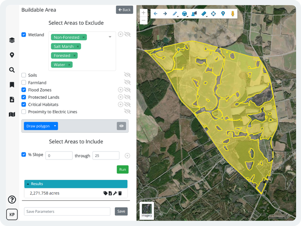
3. How do I find the solar land data I’m looking for?
Fortunately, GIS technology can help developers assess properties. As we mentioned, county data, general mapping tools, and other resources may create a disjointed view of a property while causing your team to spend more time and labor in compiling and analyzing data. With easy-to-use technology, your team will no longer need to sift through disparate data reports only to find red flags. No GIS expertise is needed.
4. Which GIS platform do you recommend and why?
Latapult’s data analysis tools allow developers like you to compile potential properties and narrow down the list to find those that are most suitable for your next solar development project in just a matter of minutes. The best part? Latapult integrates with Google Earth, AutoCAD, and other GIS solutions to help you move data between systems and create detailed reports.
Through our GIS tools and capabilities, customers are able to streamline processes for even more successful solar development projects.
Latapult is not only a mapping tool but a team of spatial data experts who are always at the ready. Latapult has streamlined our due diligence and outreach processes, and we are now able to capture more viable leads from the very start.
Julie Beauchemin, Business Development Director at Nexamp
Ready to find your next solar land development property? With data that spans the entire United States, Latapult is ready to track down land for your next project. Learn more about Latapult’s GIS Software for Solar Development here


