
GIS Software for Economic Development Authorities
See your region’s strengths more clearly and share its story with confidence. Latapult’s economic development software helps leaders connect opportunity with impact, guiding strategic investments that create growth, resilience, and lasting benefit for communities. With advanced economic development GIS, you can uncover your region’s true value and make a compelling case for investment that improves lives today and in the future.


Make Faster, Smarter Decisions
Why Economic Development Teams Trust Latapult

Show the full picture, not just the numbers
Traditional data sets often miss the human, cultural, or natural assets that make a region special. Latapult’s economic development GIS reveals the full landscape, from job industry data to the environment, so every decision reflects what truly matters.

Highlight what makes your region unique
Your community has unique strengths worth showcasing. Latapult makes those qualities crystal clear, helping you highlight why your region is the right place to grow and positioning your organization to capture every economic development opportunity.

Tell a story of impact, not just incentives
Communities aren’t competing in a zero-sum game. Latapult helps show how investments create positive ripple effects, strengthening local economies, supporting families, and building shared prosperity.

Connect opportunities with community needs
Without the right tools, agencies risk overlooking where development can have the greatest impact. Latapult’s economic development software aligns site potential with community priorities, ensuring new projects are positioned to thrive long-term.

Strengthen trust with transparent data
Stakeholders and partners want to see evidence. Latapult turns complex land and economic development data into clear, accessible visuals that build confidence and strengthen the case for regional growth.

Plan for today and tomorrow
Communities need strategies that deliver immediate benefits and sustain long-term progress. Latapult provides a dynamic, holistic view that helps agencies balance short-term wins with lasting investments.
Turn Regional Strengths Into Shared Success
Driving growth in communities means looking beyond maps and numbers. It requires understanding the people, places, and potential that make a region thrive, then showing how strategic investment can deliver lasting benefits for everyone.
Latapult’s economic development software makes that possible. By combining advanced economic development GIS with clear, accessible insights, agencies can better highlight regional strengths and guide economic development site selection to create the greatest positive impact.
- Reveal how infrastructure, workforce, and community assets align to
support sustainable growth
- Demonstrate regional readiness for expansion or relocation with confidence
- Build compelling proposals that attract new investment and strengthen
existing organizations
- Connect opportunities with community needs to ensure development
benefits the most people
- Share clear, data-backed insights that help stakeholders see a region’s full
potential

We work with economic development agencies nationwide. Put your trust in our experienced hands.
-
300+
Businesses nationwide
Supported in uncovering insights that transform projects.
-
50x
Faster land research
To justify, approve, and negotiate land deals quickly and strategically.
-
$1K+
In savings a month per user
On resources, labor, and more.
-
$1M+
In GIS data
Powering environmental, demographic, geospatial, and topographic insights.
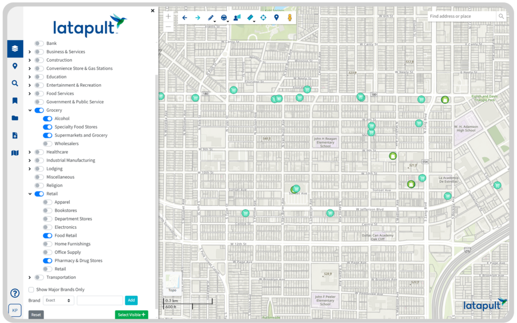
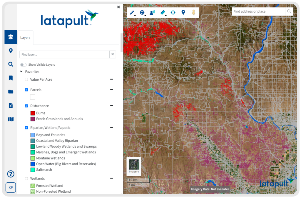
GIS Land Data Layers Built for Economic Development Agencies
Quality proposals require more than promises. They need clear, trustworthy data that shows how a region can support new opportunities and community growth. Latapult provides a holistic look at the external factors that business planners and stakeholders value most.
Key datasets include:
- Land and Environment – See flood zones, wetlands, and other
environmental factors that shape site selection potential
- Community Insights – Demographic reports, ACS Census data, and local
population trends
- Amenities and Services – Proximity to schools, healthcare, and cultural
resources that strengthen the quality of life
- Workforce and Education – Census data on job industries, labor force, and educational attainment provide insight into regional workforce capacity
- Infrastructure and Boundaries – Utilities, municipal boundaries, and
jurisdictional overlays that impact planning and investment
- Custom Data – Add your own datasets, such as training centers,
educational facilities, or other local sources, to create a view tailored to regional priorities
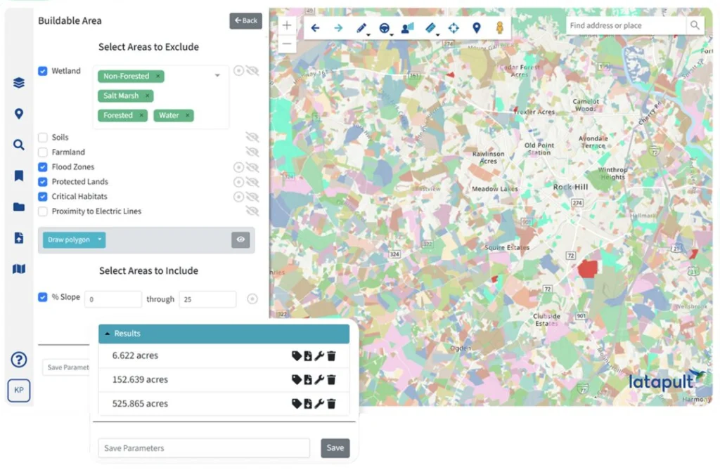
GIS Mapping Tools for Smarter Economic Development
Data matters, but it’s the way people engage with data that creates real insight. Latapult’s economic development GIS tools bring together buildable area evaluation, visual maps, and interactive charts to help agencies illustrate the benefits of land and assets in ways that inspire confident decisions.
- Run buildable area evaluations to clearly show usable land potential
- Visualize risk and reward with graphs, charts, and mapping layers
- Highlight surrounding assets and infrastructure that support long-term
growth
- Export polished maps and reports to strengthen proposals and
presentations
- Use interactive tools to demonstrate how economic development site
selection creates lasting community impact
Custom GIS Solutions for Economic Development
Every region has its own priorities, challenges, and vision for growth. Latapult can be tailored to reflect the unique data, workflows, and partnerships that drive successful economic development software adoption.
- Import and manage regional datasets, from land attributes to local reports,
to enrich proposals and presentations
- Set up workflows that track site evaluations, proposals, and investment
opportunities from start to finish
- Integrate with external tools like CRMs or project management systems to
keep teams aligned
- Collaborate directly with GIS experts who adapt Latapult to match
organizational processes and community goals


Frequently Asked Questions
-
What is economic development GIS software, and how does it help agencies?
Economic development GIS software like Latapult combines data, mapping, and collaboration tools so agencies can showcase regional strengths, attract investment, and guide site selection with confidence.
-
How do I evaluate land and community data for regional growth?
With Latapult, agencies can layer environmental, demographic, and infrastructure data to see how development projects will impact and benefit communities.
-
What tools help with economic development site selection?
GIS platforms like Latapult give agencies the ability to evaluate land attributes, amenities, and workforce data to make stronger site selection decisions.
-
Can Latapult support economic development site selection?
Yes. Latapult helps agencies evaluate land attributes, surrounding infrastructure, and community data to present compelling proposals for site selection and regional growth.
-
How can I create stronger proposals for attracting business investment?
Latapult makes it easy to combine reliable datasets with clear visuals so agencies can present proposals that highlight regional value and community potential.
-
How does Latapult improve collaboration for economic development organizations?
Latapult makes maps, proposals, and data easy to share with stakeholders, helping teams, partners, and decision-makers stay aligned around the same clear insights.
-
Is Latapult designed for both small communities and larger regions?
Absolutely. Latapult supports economic development efforts of any size, helping small towns highlight their unique assets and larger regions demonstrate complex growth opportunities.
-
Can Latapult be customized for my agency’s needs?
Yes. Our GIS experts can tailor Latapult to match regional priorities, import specific datasets, and integrate with systems like CRMs or project management tools.