
GIS Software for Residential Developers
Residential real estate development depends on more than chasing demand. Success comes from identifying the right land, visualizing subdivision potential, and moving forward with clear, data-backed decisions. Latapult’s real estate development software helps developers evaluate opportunities quickly and plan projects with confidence.


Make Faster, Smarter Decisions
Why Residential Development Teams Trust Latapult

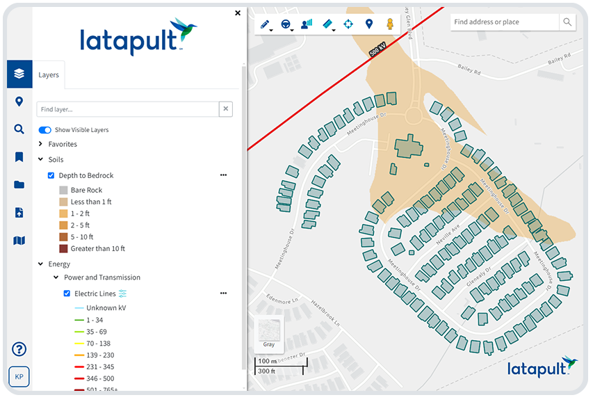
See land in terms of lots, not just parcels
Evaluating subdivision development potential can be challenging with spreadsheets and static maps. Latapult’s residential land development software helps developers visualize and analyze how land can be divided into lots that fit project goals.

Move faster without cutting corners
Manual research and piecing together disconnected data wastes time. Latapult provides accurate parcel and market information in one platform, so developers can accelerate site evaluation without missing key details.

Balance cost with opportunity
Identifying land that delivers lasting ROI and long-term investment value is complex. Latapult’s real estate mapping software surfaces the factors that matter most for profitability, risk, and sustainable growth.

See every factor that shapes a site
From FEMA flood zones to proximity to schools and amenities, outside variables can make or break a site. Latapult simplifies the application of GIS in real estate by bringing these insights together in a clear, interactive view.

Build stronger proposals for investors and partners
Residential projects succeed when stakeholders have confidence in the plan. Latapult turns complex datasets into polished visuals and reports that make subdivision development opportunities easy to understand.

Develop where communities are growing
Strong residential development depends on meeting actual demand and supporting neighborhood growth. Latapult helps developers connect subdivision planning with the housing needs of the communities they serve.
See the Lots Behind the Land
In a fast-moving housing market, residential developers need tools that make it easier to spot opportunities and move projects forward with confidence. Latapult’s real estate development software simplifies subdivision planning by turning complex land and market data into clear, actionable insight.
- Visualize how parcels can be subdivided into lots that fit project goals
- Save time by reducing manual research and consolidating data in one
platform
- Identify risks and opportunities early to protect profitability
- Share clear maps and reports that give investors and stakeholders
confidence
- Plan projects with up-to-date parcel and community information

We work with homebuilder clients nationwide in developing subdivisions. Put your trust in our experienced hands.
-
300+
Businesses nationwide
Supported in uncovering insights that transform projects.
-
50x
Faster land research
To justify, approve, and negotiate land deals quickly and strategically.
-
$1K+
In savings a month per user
On resources, labor, and more.
-
$1M+
In GIS data
Powering environmental, demographic, geospatial, and topographic insights.
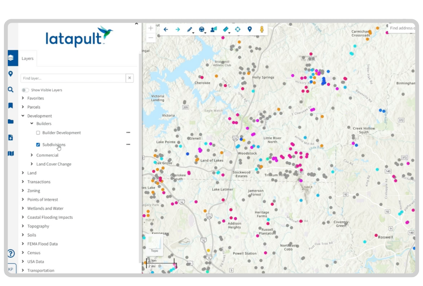
Comprehensive GIS Data for Residential Real Estate Development
Latapult takes the guesswork out of evaluating residential projects by providing the critical data developers need to make confident decisions. Our real estate mapping software consolidates parcel details, community insights, and subdivision factors to reveal project feasibility and long-term value.
Key datasets include:
- Parcel Data – Ownership records, zoning, acreage, and value per acre to
assess deal quality
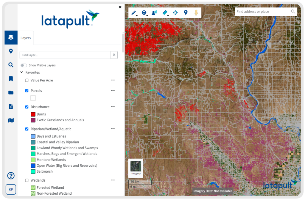
- Environmental Data – FEMA flood zones, wetlands, and other factors
that impact buildability
- Demographics and Census Data – Local population, income, and
housing trends for smarter planning
- Amenities and Points of Interest – Schools, healthcare, and community
features that influence demand
- Traffic Counts – Vehicle volume and access patterns that shape residential
site desirability
- Market and Land Value Data – Insights into pricing and trends for
competitive analysis
- Custom Data – Import project-specific or regional datasets for a complete
picture of feasibility
Land, Layouts, and Lots Made Simple
Residential real estate development requires tools that go beyond raw data. Latapult’s residential land development software makes it easier to test scenarios, visualize subdivisions, and share clear, compelling plans with stakeholders.
- Run site plan scenarios to see how parcels can be subdivided into
profitable lots
- Measure travel areas and proximity to schools, retail, and other key
amenities
- Highlight surrounding infrastructure that influences residential feasibility
- Export polished PDF maps and data tables to strengthen proposals
- Share clear visual plans that make it easier to earn stakeholder and investor
buy-in
Customizable GIS Mapping Software for Residential Development
Every development project comes with its own challenges, from evaluating lot layouts to coordinating subdivision approvals. Latapult can be tailored to match the unique data, workflows, and systems that residential developers rely on to move projects forward.
- Import and manage project-specific datasets, such as project statuses or
local land reports
- Set up workflows to track subdivision planning, site evaluations, and
project phases
- Integrate with external tools like CRMs or project management software to
streamline operations
- Work directly with GIS experts who adapt Latapult to fit residential
development processes


Frequently Asked Questions
-
What is real estate development software and how does it help residential developers?
Real estate development software like Latapult brings parcel data, subdivision tools, and planning workflows into one platform so developers can evaluate land, plan projects, and move forward with confidence.
-
How is GIS used in residential real estate development?
GIS in real estate helps developers understand land potential, from lot layouts and zoning to environmental factors and surrounding amenities. Latapult makes the application of GIS in real estate simple and accessible for residential projects.
-
How do I evaluate zoning and buildable area on a parcel?
Latapult makes it easy to layer zoning rules, parcel boundaries, and buildable area data to quickly assess residential or commercial development potential.
-
What tools help with residential site selection and feasibility?
Site selection software like Latapult helps developers evaluate parcels, infrastructure, demographics, and amenities to identify the most promising locations.
-
What datasets are included in residential land development software?
Latapult includes parcel ownership, zoning, land value, FEMA flood zones, demographics, traffic counts, and points of interest. Developers can also import custom datasets for a complete view of feasibility.
-
How does real estate development software save time for developers?
By combining mapping, data, and analysis in one platform, Latapult reduces manual research and eliminates the need to pull information from multiple disconnected sources.
-
Can Latapult support subdivision real estate projects?
Yes. Latapult provides parcel-level detail and visualization tools that help developers see how land can be subdivided into lots that align with project goals and market demand.
-
Can Latapult integrate with other real estate development project management software?
Yes. Latapult Custom can connect with tools like CRMs, project management platforms, and other systems to fit existing development workflows.