January GIS Software Updates: Latapult’s Updated Features & New Data Layers
January 5, 2022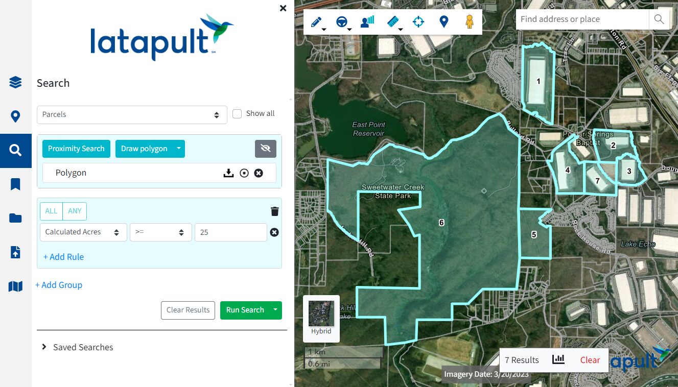
The new year often means new beginnings, and to us, that means new GIS features and layers. Our customers use the Latapult platform to find, evaluate and compare land sites, bookmark project details, and much more — and we’ve just made these workflows even easier.
We’re excited to present our New Year Release, complete with enhanced GIS software features and tools to improve team collaboration. There are also updated layers that include economic data to better evaluate and compare hot markets.
What’s been updated within Latapult’s GIS Software?
From homebuilders and real estate professionals to civil engineers and solar developers, we serve a multitude of industry professionals with various needs for GIS software. In addition to updating some of our most used tools in this latest release, we’ve added many new layer features and land data insights to further help customers make smarter land decisions. Here are a few of the new updates:
Live Bookmarks
Bookmarks allow our users to save their work for later and share it with their team. To make this tool even more impactful and collaborative, we’ve added live-editing capabilities. With Live Bookmarks, any changes made to a shared bookmark will automatically be pushed through to other users, eliminating the need for re-sharing. Plus, users never have to worry about original documentation getting lost, as the history feature allows all users to see previous versions and edits to the shared bookmark.
Improved Buildable Area Tool
Our Buildable Area tool allows users to draw or select their own boundary, and Latapult will determine the buildable area using a combination of layers, slopes, wetlands, flood zones, and more. In this release, we’ve added new functionality for transmission lines and the new prime farmland layer. Users can also create even more detailed shapes, allowing users to better evaluate and compare land sites.
Number Selected Parcels
This new feature allows users to build adjacent property exhibits by creating number labels on a map that correspond to the parcel results table. This helps users create better vicinity maps that include property boundaries and details like land value and owner information.
Other updated features include the ability to ‘favorite’ prominent or priority layers, organization-specific Latapult URLs, portrait PDF layouts, more pin symbols, and creating graphics with mobile GPS tracking.
What New GIS Layers Are Being Offered within Latapult?
With this release, users will also get access to new data layers to help them build better maps. For instance, with 2020 census data (MSA, county, and block groups), population data, and labor data that features job growth and unemployment now included within our app, users can view population changes and trends in 1 to 10-year increments and visualize where and when people travel in relation to their employment.
We’ve also added new layers and updated several other layers including:
- Soils and Farmland – outlining restricted building areas
- USA Buildings
- Topography
- Infrared Imagery
- EPA Greenbook — identifying environmental issues
- Zoning
- Airports
How Do These Updated Features Benefit Customers?
This January Release is making our GIS software more comprehensive so it can be a one-stop-shop for land professionals across a variety of industries. With these new features and data layers, Latapult is providing teams the ability for enhanced collaboration and smoother workflows, while also making project management, analysis, and comparison of hot markets easier than before.
Log in now or start your free trial to check out all these new updates for yourself. If you have questions about this release or need help navigating the new features, contact our team today.


