Cloud GIS and Interoperability Fuel Smart Multi-Stakeholder Workflows
September 17, 2025
Development projects are often complex undertakings, involving multiple agencies, private firms, and public stakeholders. Progress can stall easily when critical information is scattered across disconnected legacy systems, creating disjointed GIS data pockets that complicate communication and slow down approvals. With projects spanning various jurisdictions, the need for a single, reliable source of truth has never been more important.
Cloud-native, interoperable platforms are breaking down these barriers. By consolidating fragmented data into a centralized system, platforms like Latapult empower teams to build smarter and move faster. Embracing cloud GIS and interoperability as standard strategy components can transform your multi-stakeholder workflows, from initial site selection to final project delivery.
Interoperability in Action: From Disconnected Records to a Unified Data Foundation
True interoperability goes beyond just technical compatibility and creates a foundational system where all elements of a project work together consistently. This integrated approach supports everything from robust infrastructure planning and regulatory compliance to building more resilient communities and ensuring long-term sustainability.
Latapult’s data-driven, cloud-based GIS solutions centralize hundreds of layers into one accessible platform. As recently featured in Builder Magazine, the benefits for developers, utility engineers, and planners are significant and include:
- No more chasing fragmented records: Instead of spending valuable time hunting for information across different county offices and databases, teams can access everything they need in one place.
- A single, standardized system: A unified platform boosts collaboration by ensuring every stakeholder is working from the same files, eliminating version control issues and misunderstandings.
- Stronger project synchronization: With a clear, shared view of the project landscape, teams can make more informed decisions on site selection and research, leading to better coordination between internal and external collaborators.
Faster Approvals Through Cross-Jurisdiction Alignment
Large-scale developments often cross multiple cities, counties, or utility districts, each with its own inconsistent datasets and regulatory requirements. This lack of uniformity can spur significant delays, as teams strive to reconcile conflicting information and navigate intricate approval processes.
Latapult simplifies this challenge by aggregating city, county, state, and federal-level GIS data and applying standardized frameworks. The result — a single point of reference — maintains organization among stakeholders, from local planning departments to external engineering firms. This improved alignment accelerates project timelines through the delivery of practical outcomes, such as:
- Reduced duplication of work: When all parties have access to the same up-to-date information, redundant tasks and insight-collection efforts are eliminated.
- Accelerated permitting and approvals: A transparent, single source makes it easier for oversight agencies to review project plans, leading to faster permitting.
- Seamless collaboration: With shared, transparent data, all project participants can coordinate more effectively, reducing friction and driving continued progress.
Turn Complex Land Data into Clear, Shareable Insights
Successful project development depends on open communication with internal and external teams. Keeping investors, regulators, consultants, land developers, and community leaders on the same page is crucial for fostering trust and maintaining momentum. However, raw land and infrastructure data can be dense and difficult for non-technical associates to understand.
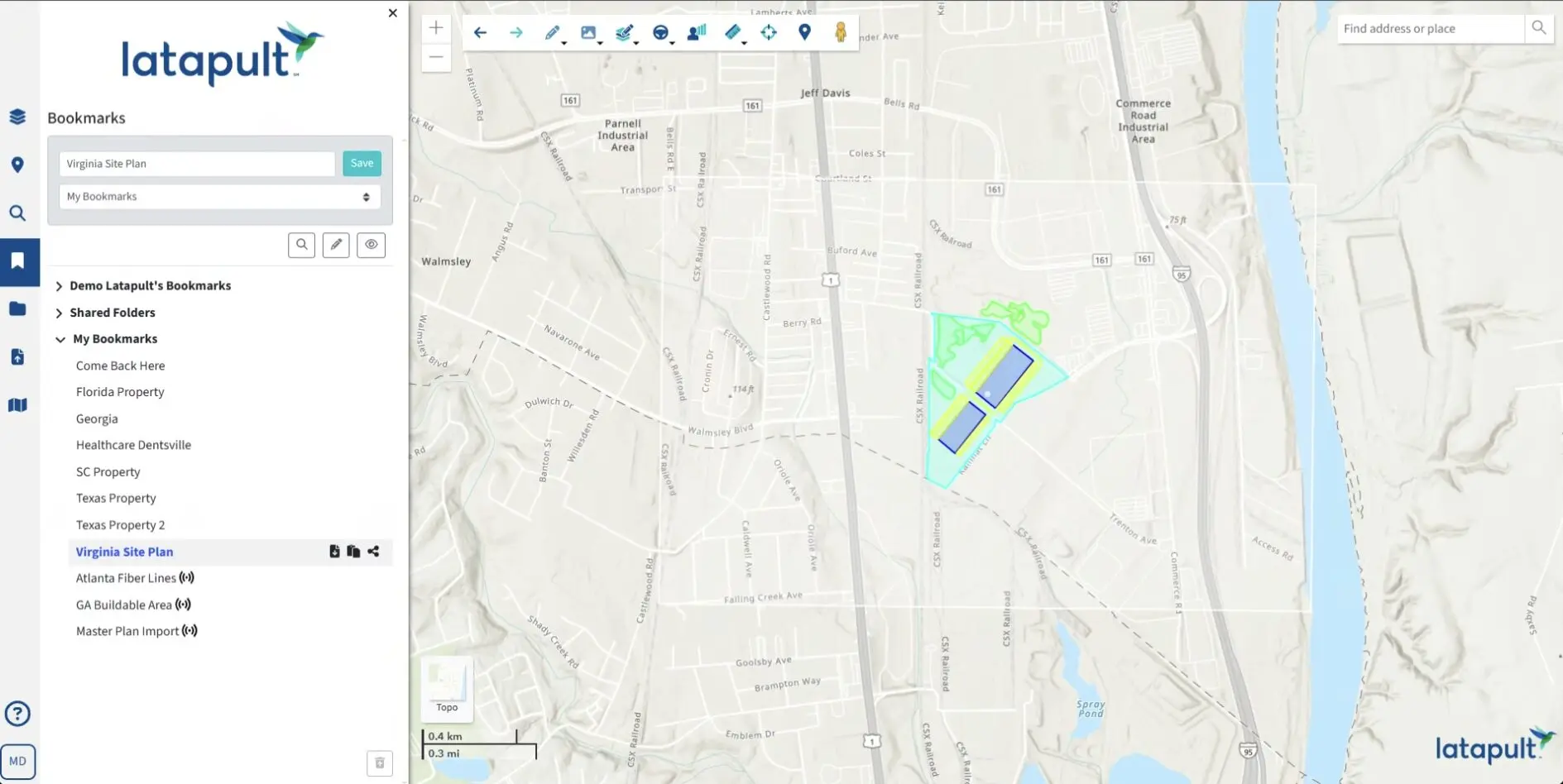
Latapult’s interactive mapping tools solve this by transforming complex data into clear, visual, and accessible insights. Information such as flood plains, soil classifications, and utility proximity can be layered onto a single map, making it easy for anyone to grasp the opportunities and constraints of a particular site. Streamlined communication and increased transparency lead to:
- Stronger trust and faster reviews: When stakeholders can easily visualize and understand the metrics behind a proposal, they are more likely to trust the project plan, strengthening and speeding review cycles.
- Fewer costly missteps: Complex GIS datasets are made easily digestible to reduce the risk of misunderstandings that can result in expensive errors or rework.
- Higher investor confidence: With access to more than 250 interoperable data layers, everyone working with Latapult users gains a comprehensive understanding of the project, boosting their confidence in its viability.
Interoperable Workflows Lower Risks and Future-Proof Projects
Relying on legacy GIS software can introduce substantial risks. Disjointed insights cause redundancy, mistakes, and delays that drain resources and derail timelines. Cloud-based GIS platforms mitigate these risks by ensuring data accuracy, simplifying version control, and establishing standardized workflows for all project participants.
Enhanced interoperability strengthens outcomes and compliance by helping teams:
- Prevent miscommunication: A single source of truth minimizes information gaps that can stall work or trigger compliance issues.
- Provide audit-ready records: Centralized, accurate inputs create a clear and defensible record for regulatory reviews.
- Support long-term sustainability: Interoperable data is more adaptable, making it easier to meet future needs and integrate with emerging technologies.
Interoperability is about more than just short-term efficiency. It’s ultimately about building a resilient foundation so projects can withstand industry challenges now and down the road.
Move Forward with Cloud GIS Interoperability
The demands of modern, multi-team projects require transparent, collaborative workflows driven by data. Legacy systems that isolate important metrics are no longer sufficient. Cloud GIS solutions deliver the interoperability that fuels faster project timelines, lowers costs, builds trust among stakeholders, and improves the end result. By unifying data and streamlining communications, platforms like Latapult empower collaborators to make smarter decisions and achieve better outcomes.
Ready to move beyond legacy GIS barriers? Let’s talk about how you can embrace Latapult’s cloud-native architecture to analyze data in real time, collaborate seamlessly, and scale your projects faster.