It’s Time to Build Smarter and Move Faster with Innovative New Features
August 13, 2025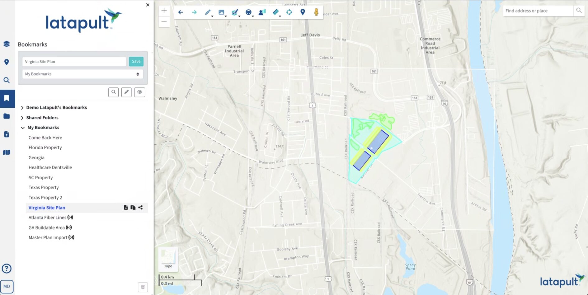
In today’s market, land acquisition, development and infrastructure teams, builders, and engineers are feeling the pressure to deliver projects faster, make smarter site decisions, and stay ahead of growing industry complexity. Latapult’s newest tools and enhanced features are designed to address these challenges by simplifying workflows, reducing risks, and aligning internal and external teams more effectively.
Whether it’s enabling real-time collaboration, making shared maps accessible to all stakeholders, or improving project visibility, the newest Latapult features demonstrate exactly why we are the go-to GIS platform for forward-thinking developers.
Shared External Bookmark Folders Provide Map Access to Anyone — Even Non-Latapult Users
Collaboration is officially free of boundaries! Restrictions misalign internal and external teams, delaying approvals and creating version-control headaches. Now, External Shared Bookmark Folders eliminate those roadblocks by letting users share live, interactive maps with anyone — including project collaborators without a Latapult account. Here’s how it works:
- Share one always-current bookmark with all team members, eliminating the confusion of multiple versions and the hassle of repeatedly re-sharing the same files.
- Enable real-time collaboration across and between organizations, avoiding siloed communication.
- Ensure non-Latapult users see the same project updates everyone else sees. Let them go beyond a static PDF and explore boundaries, buildable area outputs, texts, and imported CAD site plans – alongside a view-only version of datasets saved in the bookmark – like parcel outlines, wetlands, and topography layers.
Teams can now move faster and cut down on miscommunication, all while offering stakeholders deeper, more meaningful insight into projects.
Enhanced Pins Let Users Track What Matters, Where it Matters
Keeping track of site-specific details is now simpler than ever. Latapult’s improved Pins functionality lets you group and manage project markers and critical information across sites. Here’s how it works:
- Create Shared Pin Groups for each customer or project to keep details organized and separate.
- Smaller teams in larger entities can easily manage Pins across a company with Organization-Level Pins, granting everyone in an organization automatic access to updated information on all projects.
With Pins keeping everyone on the same page, duplicative work is history. Whether teams are tracking environmental hazards or marking infrastructure locations, they can respond to evolving project needs in record time.
Overlay and Align Any Map or Drawing with the Rubber Sheet Tool
Every project involves a variety of file types that aren’t always GIS-ready. Juggling utility maps, plats, drawings and other visuals on outside systems can waste time and energy. The new Rubber Sheet Tool makes it easy to bring them directly into Latapult’s platform and align them accurately. Here’s how it works:
- Upload and overlay site plans, historical imagery, and even more specialized files, like PDFs containing project-specific utility data and other hyper-local details.
- Adjust and align them with GIS layers so all project data lives in the same visual workspace.
Integrating vital site details – and skipping tedious reformatting and CAD workarounds — syncs all stakeholders on the same geospatial view.
KML Export Offers Unrestricted Project Sharing
Sometimes, project collaborators need access to data outside of Latapult’s platform. The KML Export feature makes it a snap to package and share information in universally compatible formats that anyone, including those without GIS expertise, can use. Here’s how it works:
- The feature enhances Latapult’s popular Bookmark tool, which lets users organize bookmarks in project folders. Now, they can download an entire folder of bookmarks into a single KML file.
- Share multiple project site graphics externally in a universal, condensed file format, allowing outside team members to easily view and utilize orderly mapping data on most other GIS platforms.
No one is left out of the loop. You can ensure maximum impact and impress partners by letting them see a project’s complete scope in a format they can easily navigate.
Expanded Data Layers Offer a Bird’s Eye View of Site Potential and Risks
Overlooking critical site data is a surefire way to create expensive problems later. Latapult offers over 250 continually refreshed and expanded data layers — far more than most other mapping platforms — covering everything from transmission lines and substations to natural gas lines, fiber lines, and environmental risk indicators. Here’s how it works:
- Instantly access national-level datasets, including ones you might not know you needed, to evaluate infrastructure faster and accelerate permitting, thanks to stronger due diligence.
- Combine infrastructure availability data with environmental and regulatory information to build a complete site profile for each deal.
Ultimately, better data up front leads to stronger investor trust and fewer surprises during development. In the development industry, reputation is everything. Start building one that precedes you.
Innovation That Solves Real Problems
Every one of these tools and enhancements was built to address persistent challenges developers face every day, from minimizing miscommunication to providing a fuller, more accurate picture of site risks. The updates are a major step forward in Latapult’s goal of empowering teams to move faster, collaborate more efficiently, and make smarter decisions. Ready to test out these powerful new solutions? Schedule a call with us today and learn how innovation fuels real-world impact.