
Unlock Your New Power: Boosting Real Estate Marketing with GIS
June 19, 2023
Unlock Your New Power: Boosting Real Estate Marketing with GIS
GIS can be a valuable tool for real estate marketing. Really, it can! Let us explain.
Have you ever wanted to break into a new market, but weren’t quite sure where to start? By using GIS software, real estate professionals can map out properties and their surrounding areas to gain a better understanding of the local market. From there, they can use the information to boost effective buying, selling and marketing strategies. Keep reading for the specifics.
Understanding the Real Estate Market Through Data
As real estate teams expand into new markets, they need to first get a lay of the land. We mean this quite literally. By taking advantage of GIS, real estate professionals can have a better understanding of land availability, market needs, and where there is untapped potential for buying and selling efforts. For example, real estate professionals can use GIS data to confirm land suitability for a potential client purchase, or even uncover opportunities for off-market deals.
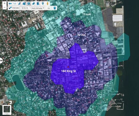
Real estate teams can also create maps within GIS platforms like Latapult to visualize property characteristics, locate nearby amenities, and more to better collaborate with clients or other agents. In turn, everyone involved in the selling or buying process is up to speed on the needs of the local real estate market in order to make better purchasing decisions. By leveraging GIS, real estate professionals can ultimately gain a competitive advantage and stand out in a crowded marketplace.
Applying GIS to Real Estate Marketing Activity
The use cases of GIS aren’t limited to just understanding the real estate market itself. Agents and brokers can take the data and visuals already created during the market evaluation process and leverage them in other business needs, like marketing. For example, the maps created to assess specific land properties can be useful in real estate listings, informational flyers, direct mailers, client texts, or other marketing materials that may be offered during property showings.
Thorough data provided within GIS can be vital to a buyer or seller as it allows them to get an initial sense of pertinent property information. For instance, it may be important for your client with a child to find a property near a park or school. Latapult offers the tools needed to identify land in close proximity to the amenities this client is focused on. By providing them with materials to visualize the location and surroundings, buying decisions can be influenced – for the better.
GIS can boost real estate marketing and sales by providing personalized, data-driven insights to help professionals target their buyers and sellers more effectively — resulting in happier clients.
Looking to boost your real estate marketing efforts? With Latapult, you’re in luck! Try it for yourself. Sign up for a FREE trial today.


