GIS Software Is Learning to Listen With AI
October 12, 2026
Latapult’s AI assistant, Coco, gives clients a conversational way to learn GIS software, run land searches, and pull insights from 250+ verified data layers. This blog covers what Coco can do today, previews Latapult’s upcoming mobile app and natural language search, and explains how AI-assisted support, paired with Regions Plus project tracking, opens land intelligence to executives, investors, and every stakeholder in the site selection process.
Key Takeaways
- Coco teaches clients how to run land searches, pull relevant insights, and complete tasks in Latapult by answering plain-language questions, all grounded in verified, source-traceable data.
- Latapult’s upcoming mobile app and natural language querying will let clients ask complex geospatial questions in plain English and take land intelligence into the field.
- Paired with Regions Plus project tracking, AI-assisted support reduces dependency on a single GIS analyst, giving leadership direct visibility across every market and deal.
GIS software has always been powerful, but it has historically come with a steep learning curve. Complex query languages, specialized training, and a reliance on dedicated GIS staff to translate business questions into technical searches have kept land intelligence in the hands of a few specialists.
AI and natural language processing are poised to remove that barrier. Instead of building a query step by step, clients can ask a conversational question and get a clear, data-backed path to the answer. Latapult has long maintained that the smartest AI depends on the data behind it, and that principle shapes how AI works inside the platform.
This shift isn’t about replacing GIS expertise; it’s about extending it, a philosophy reflected throughout why teams choose Latapult as their land intelligence platform. For leadership overseeing multiple markets and teams, that extension means fewer questions funnel through a single analyst, and more of the organization can tap directly into the same verified data.
Coco: An AI Assistant Built on Verified Data for GIS Software
Coco is Latapult’s AI-powered assistant. It teaches clients, in a conversational way, how to run land searches, pull relevant insights, and complete tasks across the Latapult platform.
Consider a client in the early stages of site selection for a new 50-acre residential development in South Carolina. Rather than digging through tutorials or waiting on a GIS analyst, they can ask Coco questions such as:
- How do I find parcels greater than 20 acres in South Carolina?
- How do I visualize environmental barriers to new construction within parcels?
- How do I export a list of parcels?
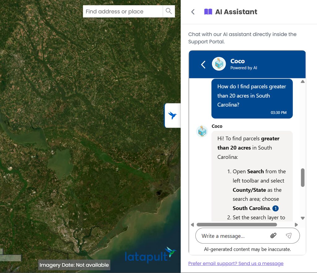
Coco guides clients through Latapult’s 250+ verified data layers and mapping tools, all designed by GIS specialists who understand land analysis and site selection workflows firsthand. Unlike a black-box chatbot guessing at answers, Coco points clients toward the platform’s structured, verified datasets. The results clients pull are ones they can trust and trace back to the source.
That distinction matters because generative AI tools can fabricate parcel insights or site constraints when asked questions outside their training. Verified data paired with conversational guidance closes the gap between having data and getting an answer. That traceability is the key difference between a convenient answer and a defensible one, and it matters most when the decision on the other end involves real capital.
What’s Coming Next to Latapult
Latapult is preparing to launch a brand-new mobile app, coming soon to app stores, that brings the platform’s tools and functionality to mobile devices in a whole new way. For teams walking a site or meeting stakeholders in the field, land intelligence will travel with them. Clients can sign up for the Latapult newsletter to hear the moment it becomes available.
Latapult is also building natural language querying directly into the platform. Clients will be able to ask complex geospatial questions in plain English, such as “show me properties that are 100+ acres within a distance of an interstate,” and get results without manually building a multi-step query.
Natural language querying simplifies multi-step tasks, like running detailed parcel queries and preparing proposal-ready reports, extending what Coco does today into a fuller conversational experience. Faster answers only matter if they hold up, so these features are built to speed up the process without asking anyone on the team to trust an unverified result.
How Land Developers Can Use AI in Site Selection
AI-assisted tools are a starting point for research, not a replacement for full due diligence. Here’s how that process looks with Latapult today and in the near future:
- Build an initial shortlist: Use Coco to learn how to filter parcels by acreage, location, and other criteria during early-stage site selection.
- Track due diligence in one place: As sites move forward, keep findings, constraints, and status updates organized in Latapult, a necessity now that commercial development has entered a data-driven due diligence era.
- Ask broader questions faster: When natural language querying rolls out, clients will be able to ask wide-ranging questions without manually building a query, while deeper, defensible analysis still depends on Latapult’s underlying data accuracy.
Catching an incompatible constraint, like a wetland, a flood zone, or limited utility access, at this early stage keeps significant capital from being committed to a flawed assumption. The earlier an issue surfaces, the less it costs to walk away.
Opening Land Intelligence to the Whole Team
AI-assisted support doesn’t just speed up work for GIS specialists. It reduces the dependency on a single technical expert to explain every tool, dataset, and query.
With Regions Plus, executives, investors, and other stakeholders can track project pipelines through shared, editable tracking layers, so the entire land development team stays on the same page. These non-technical stakeholders can ask Coco how to find the data they need within a project rather than waiting on an analyst to run every report.
That wider access shortens the distance between a question and a decision across every market and deal, letting more people contribute to site selection conversations earlier in the process. For leadership, visibility is no longer limited to whatever gets reported up the chain. They can look directly at what’s happening across markets and deals whenever they need to.
Faster, Verified Answers for Every Team Member
Coco already gives clients a faster, more conversational way to learn and navigate Latapult’s GIS software. The upcoming mobile app and natural language search are the next steps in extending that access even further.
Paired with Regions Plus project tracking, more people across an organization, not just GIS specialists, can follow the pipeline and get trustworthy, data-backed answers. That combination of speed and accessibility, built on verified data and geospatial expertise, gives teams room to move quickly on site opportunities while giving leadership confidence that nothing important was missed along the way.
Connect with us to see how Coco can support your team’s site selection process today and give your leadership a faster, more confident way to protect capital across every deal.
Frequently Asked Questions
-
What is an AI assistant for GIS software?
An AI assistant for GIS software, like Latapult’s Coco, teaches clients how to run land searches, pull insights, and complete tasks by answering questions in plain language. Latapult’s Support Center offers additional resources as these AI features continue to expand.
-
How accurate is AI when analyzing land or GIS data?
AI is only as reliable as the data behind it. That’s why Coco guides clients toward Latapult’s 250+ verified data layers rather than relying on an open-ended model that could fabricate parcel insights or site constraints.
-
Do you need GIS experience to use AI-powered land search?
No. Coco is built to help non-technical clients, like executives, investors, and acquisition managers, learn how to find the data they need without relying on a dedicated GIS analyst.
-
How does AI improve site selection for land developers?
AI speeds up early-stage site selection by helping developers build an initial shortlist of parcels and surface relevant insights faster. Latapult keeps every finding tied to verified data as due diligence moves forward.
-
How does Latapult compare to Prophetic and other AI-native land platforms?
Like Prophetic and other AI-native land platforms, Latapult uses AI to help land teams find answers faster. The difference is the foundation: Latapult’s AI assistant, Coco, was designed by GIS experts and is grounded in more than 250 GIS data layers that are already verified, so clients don’t have to dig through raw data to trust what they find.